Giro Rosa 2018 Route stage 5: Omegna - Omegna
Slideshow 1/14
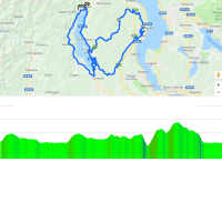
Tuesday, 10 July 2018 - The 5th stage on the Giro Rosa sets off in Omegna to finish there as well. The hilly route amounts to 117.7 kilometres.
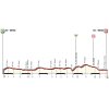
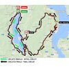
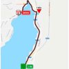
Stage 5 in the Giro Rosa includes two loops. At 36 kilometres, the first one travels around Lago d’Orta. Once the flag is dropped the route climbs up a 4.6 kilometres hill with an average gradient of 3.6%. The course remains as good as flat after this climb.
The first half of the second loop is a copy of the first half of the first round. Just after the southernmost point of Lago d’Orta, when it goes north again, the route turns right in the direction of Lago Maggiore. The area between the lakes is much hillier and the going gets tougher. The steep Monte Rosa appears after approximately 80 kilometres. It’s a 3.8 kilometres toil at 8.8%.
The first rider over the Monte Rosa faces 34.8 more kilometres to the line. First a rolling section before a short descent leads to a 4.8 kilometres climb at 4.3%. A descent of 16 kilometres leads to the final 11 kilometres on the flat.
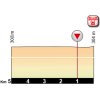
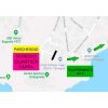
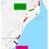
The finale is familiar as it is played out on the last part of the first loop. That is, except for the final 300 metres. The riders turn left on the Lungolago Gramsci to finish directly next to the Lago d’Orta.
The first three riders on the line win time bonuses of 10, 6 and 4 seconds, while the intermediate sprint (at kilometre 104.3) comes with 3, 2 and 1 seconds.
Read also: results/race report 5th stage 2018 Giro Rosa.
Giro Rosa 2018 stage 5: Route maps, height profiles, and more
Click on the images to zoom
+ Click for more images (10)
Watch the highlights of recent races here:
Leave a comment
2 comment(s)
Related articles Overview - Giro Rosa 20 Stage 10: Annemiek van Vleuten wins final stage and GC - Giro Rosa 20 Stage 9: Van Vleuten cements lead with Zoncolan victory - Giro Rosa 20 Stage 8: Marianne Vos sprints to victory, Annemiek van Vleuten still in pink - Giro Rosa 20 Stage 7: Annemiek van Vleuten climbs to mountain time trial win and maglia rosa - Giro Rosa 20 Stage 6: Mountain top victory brings Amanda Spratt maglia rosa - Giro Rosa 20 Stage 4: Jolien D'Hoore again, Leah Kirchmann still in pink - Giro Rosa 20 Stage 3: Jolien D'Hoore powers to sprint win, Leah Kirchmann new leader - Giro Rosa 20 Stage 2: Sprint victory Kirsten Wild, Lucinda Brand new leader - Giro Rosa 20 Stage 1: Team Sunweb wins TTT, Ellen van Dijk first maglia Rosa - Giro Rosa 20 Route stage 1: TTT in Verbania - Giro Rosa 20 Route stage 2: Ovada - Ovada - Giro Rosa 20 Route stage 3: Corbetta- Corbetta - Giro Rosa 20 Route stage 4: Piacenza - Piacenza - Giro Rosa 20 Route stage 6: Sovico - Gerola Alta - Giro Rosa 20 Route stage 7: Lanzada - Campo Moro - Giro Rosa 20 Route stage 8: San Giorgio di Perlena - Breganze - Giro Rosa 20 More articles Tour of Flanders 2025: The Route
Tour of Flanders 2025: Riders
Tour of Flanders 2025: Favourites
Tour of Flanders 2025 - women: The Route
Tour of Flanders 2025 - women: Riders
Tour of the Basque Country 2025: Route
Tour of the Basque Country 2025: Riders
Tour of the Basque Country 2024: GC Favourites
Tour of the Basque Country 2025 Route stage 1: Vitoria-Gasteiz - Vitoria-Gasteiz
Tour of the Basque Country 2025 Route stage 2: Pamplona - Lodosa
Tour of the Basque Country 2025 Route stage 3: Zarautz - Beasain
Tour of the Basque Country 2025 Route stage 4: Beasain - Markina-Xemein
Tour of the Basque Country 2025 Route stage 5: Urduña - Gernika-Lumo
Tour of the Basque Country 2025 Route stage 6: Eibar - Eibar
Paris - Roubaix 2025: The Route
Paris - Roubaix 2025: Riders
Paris - Roubaix Femmes 2025: Route
Paris - Roubaix Femmes 2025: Riders
Amstel Gold Race 2025: The Route
Tour de France 2025: The Route
Tour de France 2025 Route stage 1: Lille - Lille
Tour de France 2025 Route stage 12: Auch - Hautacam
Tour de France 2025 Route stage 14: Pau - Superbagnères
Tour de France 2025 Route stage 16: Montpellier - Mont Ventoux
Tour de France 2025 Route stage 18: Vif - Col de la Loze
Cycling Calendar 2025
Volta a Catalunya 2025: Sprint triumph Brennan, Ayuso reclaims GC lead
Giro 2025: The Route
Giro 2025 Route stage 1: Durazzo - Tirana



Can you confirm the stage 5 route for Giro Rosa. I get different information from Giro Rosa pages!
Hi Mikko
We have user the information from the roadbook. But that one was not very clear.. But We are quite sure that out information is correct.