Vuelta Femenina 2024 Route stage 6: Tarazona - La Laguna Negra
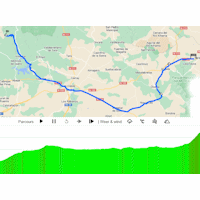
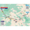
 Friday 3 May - The 6th stage of La Vuelta Femenina travels to the Picos de Urbión. The route covers 132 kilometres, while the finishing climb to La Laguna Negra ascends over 6.5 kilometres at 6.8%. The last kilometre ramps up at double digits.
Starting venue Tarazona is situated at an elevation o 524 metres and the riders traverse a false flat over the first 30 kilometres to reach a plateau at over 1,000 metres. They remain at that altitude for the rest of the day. The roads are mostly flat until the finale begins.
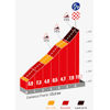
Following the intermediate sprint in Vinuesa, the road starts to incline slighly and 10 kilometres later the riders enter the finishing climb. The ascent to La Laguna Negra is 6.5 kilometres long and slopes at 6.8%. It comes down to the last 1.5 kilometres, as this section ascends at 9%. The final 500 metres even ramp up to 11.2%.
La Laguna Negra is located in the Picos de Urbión mountain range. It’s possible to hike from the lake to the highest peak, Pico Urbión, at an elevation of 2,228 metres.
The first three riders on the line gain times bonuses of 10, 6 and 4 seconds, while the intermediate sprint comes with 6, 4 and 2 seconds.
Ride the route yourself? Download GPX 6th stage 2024 Vuelta Femenina.
Another interesting reads: results 6th stage 2024 Vuelta Femenina.
La Vuelta Femenina 2024 stage 6: route & profiles
Click on the images to zoom
Watch the highlights of recent races here:
Leave a comment
No comments yet, your opinion is most welcome.
Related articles Vuelta Femenina 2024: Vos wins hilltop sprint, Vollering still leader Vuelta Femenina 2024: Muzic wins at La Laguna Negra climb, Vollering cements GC lead Vuelta Femenina 2024: Vollering climbs into red jersey Vuelta Femenina 2024: Faulkner wins with late attack, Vos new leader Vuelta Femenina 2024: Vos sprints to victory, Vas still leader Vuelta Femenina 2024: Jackson wins chaotic sprint, Vas new leader Vuelta Femenina 2024: Lidl-Trek wins TTT, Realini take first red jersey Vuelta Femenina 2024 Route stage 1: Valencia TTT Vuelta Femenina 2024 Route stage 2: Buñol - Moncafa Vuelta Femenina 2024 Route stage 3: Lucena - Teruel Vuelta Femenina 2024 Route stage 5: Huesca - Jaca Vuelta Femenina 2024 Route stage 4: Molina de Aragón - Zaragoza Vuelta Femenina 2024 Route stage 7: San Esteban de Gormaz - Sigüenza Vuelta Femenina 2024 Route stage 8: Alcobendas - Valdesquí Vuelta Femenina 2024 stage 1: Start times Valencia TTT Vuelta Femenina 2023: The Route Vuelta Femenina 2023: RidersMore articles Summer Olympics 2024 Paris: Route ITT (m/w)
Summer Olympics 2024 Paris: Start list + times ITT – men
Summer Olympics 2024 Paris: Start list + times ITT – women
Summer Olympics 2024 Paris: Route road race – men
Summer Olympics 2024 Paris: Riders road race – men
Summer Olympics 2024 Paris: Route road race – women
Summer Olympics 2024 Paris: Riders road race – women
Clásica de San Sebastián 2024: The Route
Tour de France Femmes 2024: The Route
Tour de France Femmes 2024 Route stage 1: Rotterdam - The Hague
Tour de France Femmes 2024 Route stage 2: Dordrecht - Rotterdam
Tour de France Femmes 2024 Route stage 3: Rotterdam ITT
Tour de France Femmes 2024 Route stage 4: Valkenburg - Liège
Tour de France Femmes 2024 Route stage 5: Bastogne - Amnéville
Tour de France Femmes 2024 Route stage 6: Remiremont - Morteau
Tour de France Femmes 2024 Route stage 7: Champagnole - Grand-Bornand
Tour de France Femmes 2024 Route stage 8: Grand-Bornand - Alpe d'Huez
Vuelta 2024: The Route
Vuelta 2024 Route stage 6: Jerez de la Frontera - Yunquera
Cycling Calendar 2024
Tour de France 2024: Withdrawals


