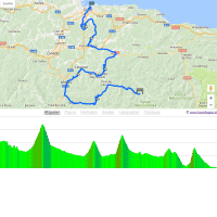
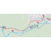
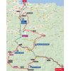
Redes Natural Park in located in Asturias. The peloton leaves from the village Caso to ride to the base of the first climb. The 7 kilometres up the Alto de Colladona are marked by a 6.8% gradient, while the peak is crested at kilometre 29.
A long descent takes the riders to the foot Alto de San Emiliano – 6.8 kilometres at 4.5% -, shortly followed by the Alto de la Falla de los Lobos, a 4.3 kilometres climb at 8.2%. The Falla de los Lobos is crested with 65 kilometres remaining.
On rolling roads the route continues until a drop takes the riders almost down to sea level. It’s there the Alto de San Martin appears, the last climb of the day starts with a false flat of more than 1 kilometer before the last 3 kilometres go up at almost 10%. A plunge down of 15.2 kilometres leads to to the finish in Gijón.
In the 1940’s Delio Rodríguez took five stage wins in Gijón. More recently Serguéi Smetanin (2002) and ONCE (2003, TTT) powered to the win in the town on the Bay of Biscay.
The first three riders on the line take time bonuses of 10, 6 and 4 seconds, while the intermediate sprint (at kilometre 112.2) comes with 3, 2 and 1 seconds.
Read also: results/race report 19th stage 2017 Vuelta.
Vuelta 2017 stage 19: Route maps, height profiles, and more
Click on the images to zoom
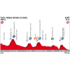
 Details start 19th stage
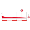 Final kilometres 19th stage
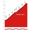 Climb details Alto de la Colladona
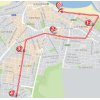 Details finish 19th stage

 Instagram @lavuelta

Videos La Vuelta

Video: highlights 2016
 Vuelta a España Tweets