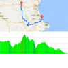
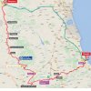
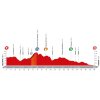
On rolling roads the riders head for Ayora, a municipality located at the foot of the Puerto de Casa del Alto. The only KOM climb (2nd category) of the day peaks at 1,085 metres.
After cresting Alto del Pelegrin there are 130 kilometres left to race. With some minor uphill hick-ups the riders plunge down to Moixent before a long false flat takes them to a 70 kilometres section that’s almost entirely a downward, yet modest incline.
Arrival place Gandia lies near the coast and with 200,000 inhabitant it’s a thriving centre of commerce. Located in the Valencian Country, the region is well known to most riders as it offers perfect training grounds, especially in winter. The possibilities are endless. Near Gandia there are flat and straight roads along the coast that are perfect to hone your skills in regard to echelons, while inland you’ll find all sorts of climbs everywhere.
Expect this stage to boil down to a bunch sprint in the streets of Gandia.
At the finish wait 10, 6 and 4 seconds for the first three riders, and 3, 2 and 1 seconds can be gained at the intermediate sprint after 147 kilometres.
Results/race report 18th stage, 2016 Vuelta.
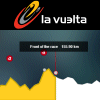
Vuelta a España 2016 Stage 18: Route maps, height profiles, etc
Click on the images to zoom
Related articles Riders - Vuelta 2016 Route and stages - Vuelta 2016 GC Favourites - Vuelta 2016 More articles Summer Olympics 2024 Paris: Route ITT (m/w)
Summer Olympics 2024 Paris: Start list + times ITT – men
Summer Olympics 2024 Paris: Start list + times ITT – women
Summer Olympics 2024 Paris: Route road race – men
Summer Olympics 2024 Paris: Riders road race – men
Summer Olympics 2024 Paris: Route road race – women
Summer Olympics 2024 Paris: Riders road race – women
Clásica de San Sebastián 2024: The Route
Tour de France Femmes 2024: The Route
Tour de France Femmes 2024 Route stage 1: Rotterdam - The Hague
Tour de France Femmes 2024 Route stage 2: Dordrecht - Rotterdam
Tour de France Femmes 2024 Route stage 3: Rotterdam ITT
Tour de France Femmes 2024 Route stage 4: Valkenburg - Liège
Tour de France Femmes 2024 Route stage 5: Bastogne - Amnéville
Tour de France Femmes 2024 Route stage 6: Remiremont - Morteau
Tour de France Femmes 2024 Route stage 7: Champagnole - Grand-Bornand
Tour de France Femmes 2024 Route stage 8: Grand-Bornand - Alpe d'Huez
Vuelta 2024: The Route
Vuelta 2024: Riders
Vuelta 2024 Route stage 1: Lisbon - Oeiras
Vuelta 2024 Route stage 2: Cascais - Ourém
Vuelta 2024 Route stage 3: Lousã - Castelo Branco
Vuelta 2024 Route stage 4: Plasencia - Pico Pitolero
Vuelta 2024 Route stage 5: Fuente del Maestre - Seville
Vuelta 2024 Route stage 6: Jerez de la Frontera - Yunquera
Vuelta 2024 Route stage 7: Archidona – Córdoba
Cycling Calendar 2024
Tour de France 2024: Withdrawals