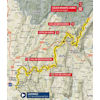
Following a flat opener the Col de Montgriffon appears after 28 kilometres. The climb is 12.5 kilometres long and the average gradient sits at 4.1%, while there is no such thing as a descent at the top. The road continues to climb gradually in undulating style until the Col de Cuvillat appears after roughly 50 kilometres. This is a short test: 3.4 kilometres at 7.4%.
A short and steep downhill runs onto a non-classified ascent and a false flat of around 10 kilometres. The riders are halfway when it is time for the first proper descent.
The Côte de Giron begins in Saint-Germain-de-Joux. It is a 7.6 kilometres climb with an average gradient of 6.2%. After 1 kilometre of plateau at the top and a short kick-up the riders fly downhill into the valley.
Still 30 kilometres to go at the foot of the Col de Menthières. The first 9.1 kilometres climb at 6.3% before the descent of the Menthières takes the riders to Chézery-Forens, which is where the last ascent commences. The climb to Lélex is 12 kilometres and in terms of gradients it is nothing special, as it mostly hovers around 3%.
The 2016 Tour de l’Ain finished in Lélex Monts-Jura with Sam Oomen outsprinting Pierre Latour, Bart Declercq, Guillaume Martin and David Gaudu on the line.
The intermediate sprints come with 3, 2 and 1 seconds, while time bonuses of 10, 6 and 4 seconds are awarded to the first three riders on the line.
Another interesting read: results 2nd stage 2020 Tour de l’Ain.
Tour de l’Ain 2020 stage 2: route, profile
Click on the images to zoom