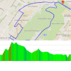
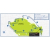
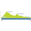
The Grand Prix Cycliste de Montréal sets off on Avenue du Parc and shortly after the start the riders tackle the Côte Camillien-Houde. The climb in Parc du Mont-Royal is 1.8 kilometres at 8%. On winding roads the metropolis of Montréal seems very far away indeed.
After cresting the Camillien-Houde the riders plunge down a steady drop and following 1 kilometre on the flat the next climb appears. The Côte de la Polytechnique is 780 metres at 6%, while a 200 metres ramp at 11% kicks in hard. This is the steepest stretch in each round.
Following the Côte de la Polytechnique the riders turn left to drop down Chemin de la Rampe, which is a steep descent with some tight turns. Once down, the wide Chemin de la Côte Ste-Catherine leads back to Avenue du Parc. An U-turn with 560 metres left takes the riders to the finish line on a wide road with a 4% gradient.
A each lap features 229 vertical metres, the full route amounts to 3,893 vertical metres.
Greg Van Avermaet is title defender. Last year, the Olympic Champion outsprinted Peter Sagan and Anthony Roux.
Read also: results/race report 2017 Grand Prix de Montréal.
Grand Prix Cycliste de Montréal 2017: Route map, height profile, and more
Click on the images to zoom
Related articles Overview - Grand Prix Cycliste de Montréal 2017 More articles Summer Olympics 2024 Paris: Route ITT (m/w)
Summer Olympics 2024 Paris: Start list + times ITT – men
Summer Olympics 2024 Paris: Start list + times ITT – women
Summer Olympics 2024 Paris: Route road race – men
Summer Olympics 2024 Paris: Riders road race – men
Summer Olympics 2024 Paris: Route road race – women
Summer Olympics 2024 Paris: Riders road race – women
Clásica de San Sebastián 2024: The Route
Tour de France Femmes 2024: The Route
Tour de France Femmes 2024 Route stage 1: Rotterdam - The Hague
Tour de France Femmes 2024 Route stage 2: Dordrecht - Rotterdam
Tour de France Femmes 2024 Route stage 3: Rotterdam ITT
Tour de France Femmes 2024 Route stage 4: Valkenburg - Liège
Tour de France Femmes 2024 Route stage 5: Bastogne - Amnéville
Tour de France Femmes 2024 Route stage 6: Remiremont - Morteau
Tour de France Femmes 2024 Route stage 7: Champagnole - Grand-Bornand
Tour de France Femmes 2024 Route stage 8: Grand-Bornand - Alpe d'Huez
Vuelta 2024: The Route
Vuelta 2024: Riders
Vuelta 2024 Route stage 1: Lisbon - Oeiras
Vuelta 2024 Route stage 2: Cascais - Ourém
Vuelta 2024 Route stage 3: Lousã - Castelo Branco
Vuelta 2024 Route stage 4: Plasencia - Pico Pitolero
Vuelta 2024 Route stage 5: Fuente del Maestre - Seville
Vuelta 2024 Route stage 6: Jerez de la Frontera - Yunquera
Vuelta 2024 Route stage 7: Archidona – Córdoba
Cycling Calendar 2024
Tour de France 2024: Withdrawals


 Instagram @grandsprixcyclistes
 Grand Prix de Montréal Tweets
 Streetview Avenue du Parc