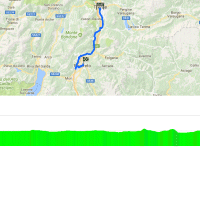
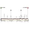
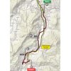
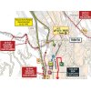
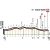
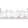
The start ramp is located in Trento, town of Leonardo Bertagnolli and the Mosers. The route runs through the Trentino-Alto Adige/Südtirol region, home of the Tour of the Alps, which is often used as a preparation for the Giro.
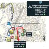
The first intermediate time check is at kilometre 12.9 in Aldeno, a village at the foot of the Monte Bondone climb. Yet, the riders leave the 2,180 metres peak alone and head further south to Rovereto.
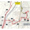
The second half of the route is more hilly. With 10 kilometres left the road points uphill for 500 metres. The first half of it rises with double digit gradients before the hill flattens out. The second intermediate check point is located just over the top.
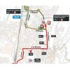
With 5.6 kilometres remaining the route climbs at 3% for 900 metres, while the ultimate kilometres begin with 600 metres at 3 to 4%. Some 500 metres before the line a small stretch of pavé appears.
The ITT ends in Rovereto, home town of the Bertolinis, of whom Alessandro is the best known member – or, the least unknown. In 2008, aged 36, he won a stage in the Giro.
Read also: results/report 16th stage 2018 Giro d’Italia.
Giro d’Italia 2018 stage 16: Route maps, height profiles, and more
Click on the images to zoom
Related articles The Route - Giro 20 Riders - Giro 20 Withdrawals - Giro 20 Route and stages - Giro 20 Favourites - Giro 20 More articles Tour of the Alps 2024: Paret Peintre wins final stage, López wins GC
Tour of the Alps 2024 Route stage 5: Levico Terme - Levico Terme
Liège-Bastogne-Liège 2024: The Route
Liège-Bastogne-Liège 2024: Riders
Liège-Bastogne-Liège Femmes 2024: The Route
Liège-Bastogne-Liège Femmes 2024: Riders
Giro 2024: The Route
Giro 2024: Riders
Giro 2024 Route stage 1: Turin - Turin
Giro 2024 Route stage 2: San Fransesco al Campo - Oropa
Giro 2024 Route stage 3: Novara - Fossano
Giro 2024 Route stage 4: Acqui Terme - Andora
Giro 2024 Route stage 5: Genoa - Lucca
Giro 2024 Route stage 6: Viareggio - Rapolano Terme
Giro 2024 Route stage 7: Foligno - Perugia
Giro 2024 Route stage 8: Spoleto - Prati di Tivo
Giro 2024 Route stage 9: Naples - Naples
Cycling Calendar 2024
Giro 2024 Route stage 10: Pompei - Bocca della Selva
Giro 2024 Route stage 11: Foiano di Val Fortore - Francavilla al Mare
Giro 2024 Route stage 15: Manerba del Garda - Livigno
Giro 2024 Route stage 16: Livigno - Monte Pana
Giro 2024 Route stage 17: Selva di Val Gardena – Passo Brocon
Giro 2024 Route stage 19: Mortegliano - Sappada
Giro 2024 Route stage 20: Alpago – Bassano del Grappa
Tour de Romandie 2024: Riders
Tour de France 2024: The Route
Tour de France 2024: Riders
Tour de France 2024 Route stage 1: Florence - Rimini
Vuelta 2024: The Route