Tour de France 2016 Route stage 2: Saint Lô - Cherbourg Octeville
Tour de France 2016 Route stage 2: Saint Lô - Cherbourg Octeville
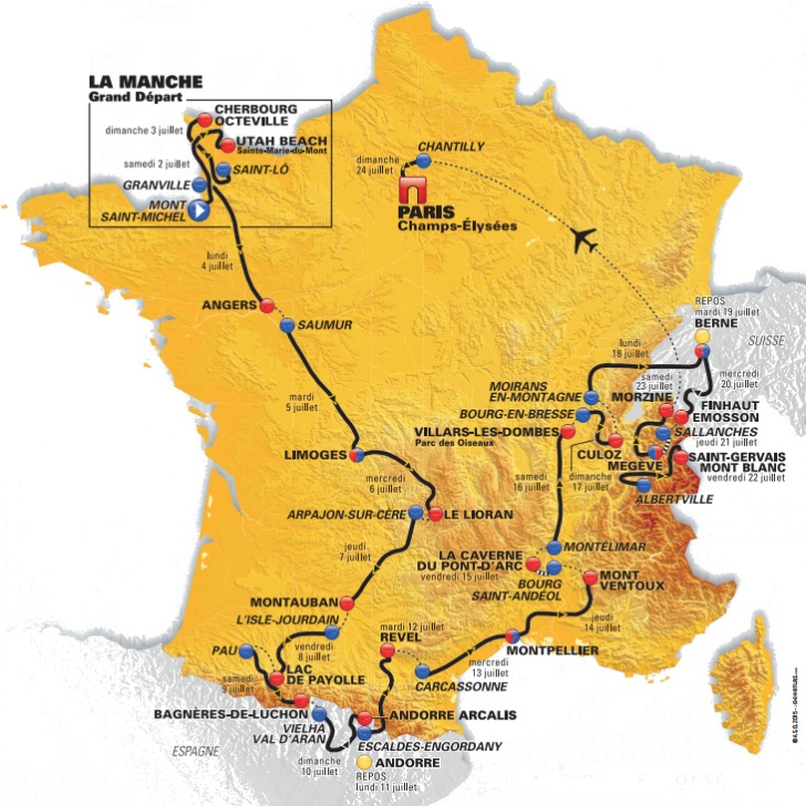
World War II is not far away at the Tour-start. Stage 1 finishes near Utah Beach, a major landing on D-Day, while stage 2 leaves from Saint-Lô. Because of its strategic location, the town in north-western France was heavily bombed during Operation Overlord.
Likewise, arrival-town Cherbourg-Octeville saw heavy fighting during the Battle of Normandy. The northernmost town on the Cotentin Peninsula was crucial because of the seaport.
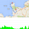
In all likelihood, today's cannon fire will be hidden in the legs of the puncheurs. The stage closes in Cherbourg-Octeville after a 3,1 kilometres closing climb up to Cherbourg Octeville. The first part is the Côte de la Glacerie - 1.9 kilometres at 6.5% with a steepest section at 14% -, than a slight descent before the last 700 metres go up at 5.7%.
Underway the riders race on the rolling roads of Normandy. Four time they are to crest a 4th category climb - Côte de Torigny-les-Villescategory (after 10 kilometres), Côte de Montabot (after 23 kilometres) and Côte de Montpinchon (after 52 kilometres). The 1.9 kilometres climb up Côte de La Glacerie is 3rd category.
The first three riders on the line take time bonuses at 10, 6 and 4 seconds.
Race report/results 2nd stage, 2016 Tour de France.
Tour de France 2016 stage 2: Route maps, height profiles, etc.
Click the images to enlarge