Grand Prix Cycliste de Montréal 2016: The Route
Totalling at 205.7 kilometres, the Grand Prix Cycliste de Montréal sets off on Avenue du Parc. After two turns to the right the Côte Camillien-Houde welcomes the riders, a 1.8 kilometres hill at 8%. On winding roads the metropolis of Montréal seems very far away indeed.
After cresting Côte Camillien-Houde with 2.1 kilometres done a relatively long drop lays waiting. Then two right-angle bends take the riders onto avenue Maréchal. Following a sharp left turn, the riders pass the buildings of the Université de Montréal before the next climb appears. The Côte de la Polytechnique is 780 metres at 6% with a 200 metres steepest section at 11%.
On top of the Côte de la Polytechnique the riders turn left to tackle Chemin de la Rampe, a steep descent with some tight turns. Once down, the wide Chemin de la Côte Ste-Catherine leads back to Avenue du Parc. Just before the drop to the Saint Lawrence River a sharp turn takes the riders to the finish line. Only 560 metres left on a road rising with a gradient of 4%.
Tim Wellens is title holder.
Live race report Grand Prix de Montréal. The finish is expected around 4:15, local time.
Grand Prix Cycliste de Montréal 2016: Route map, height profile, and more
Click the images to enlarge
 Route and profile##30
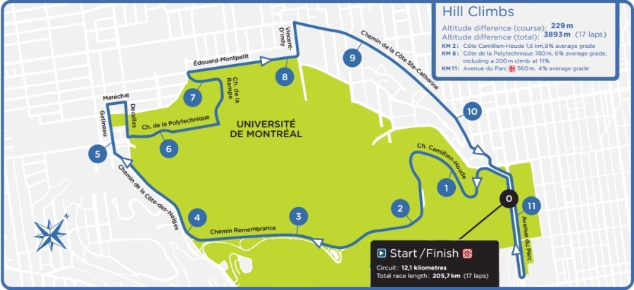 Route Grand Prix Montréal##15
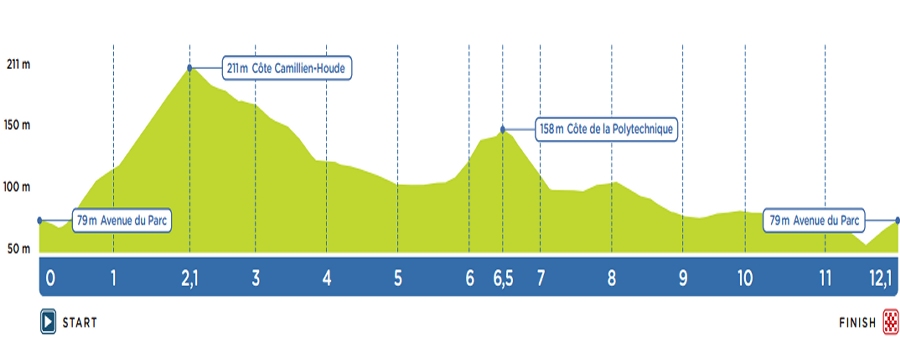 Profile Grand Prix Montréal##0
Videos Grand Prix de Montréal
 Instagram @grandsprixcyclistes
 Grand Prix de Montréal Tweets##30
 Streetview Avenue du Parc##45